


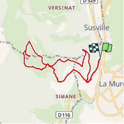
Les Hauts de la Mure

maupassant38
User

Length
9.5 km

Max alt
1226 m

Uphill gradient
372 m
Km-Effort
14.5 km

Min alt
885 m

Downhill gradient
372 m
Boucle
Yes
Creation date :
2019-03-28 09:21:53.356
Updated on :
2019-03-28 13:03:47.755
2h37
Difficulty : Easy

FREE GPS app for hiking
 SityTrail
IGN / Geographical institutes
SityTrail Plus
The world is yours!
About
Trail Walking of 9.5 km to be discovered at Auvergne-Rhône-Alpes, Isère, La Mure. This trail is proposed by maupassant38.
Positioning
Country:
France
Region :
Auvergne-Rhône-Alpes
Department/Province :
Isère
Municipality :
La Mure
Location:
Unknown
Start:(Dec)
Start:(UTM)
719667 ; 4976741 (31T) N.
Comments